
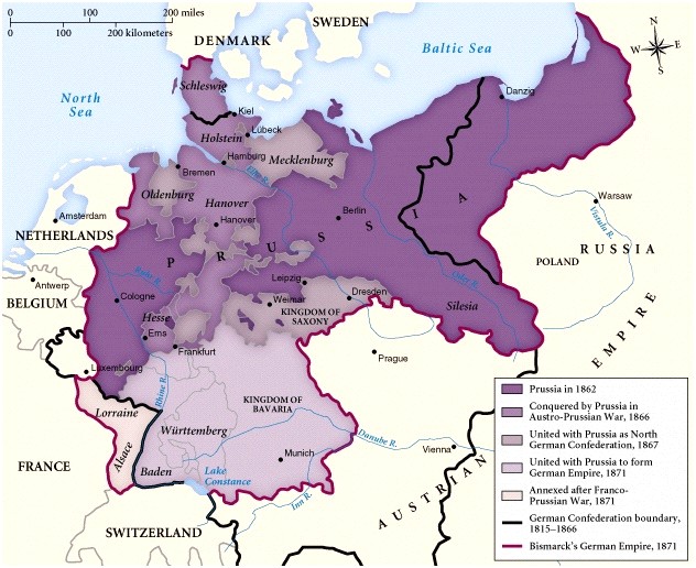
Franco-Prussian War Map
Title
Franco-Prussian War Map
Subject
John Dailinger
Description
This is a map showing the change of country boundaries as a result of the Franco-Prussian War that occurred 1870-1871
Creator
IMD Corporation
Source
<a href="http://www.miraed.net/parallelhistory/event_display_get.php?fname=Franco-Prussian%20War">http://www.miraed.net/parallelhistory/event_display_get.php?fname=Franco-Prussian%20War</a><br /><br />IMD Corporation
Publisher
IMD Corporation
Rights
<p><a href="http://www.miraed.net/">http://www.miraed.net/</a></p>
<p>"IMD provides a database of practice problem and homework problems. Anyone can make new problems and assign problems. Use the tools to create custom problems, bundle problems into assignments, give assignments, and then receive the returned answers."</p>
<p>"IMD provides a database of practice problem and homework problems. Anyone can make new problems and assign problems. Use the tools to create custom problems, bundle problems into assignments, give assignments, and then receive the returned answers."</p>
Format
.jpg
Identifier
francoprussianwar
Coverage
1870-1871
Citation
IMD Corporation, “Franco-Prussian War Map,” Graffiti Soldiers, accessed October 21, 2026, https://drstephenrobertson.com/Graffiti_Soldiers/items/show/485.